 © TU Berlin
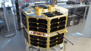
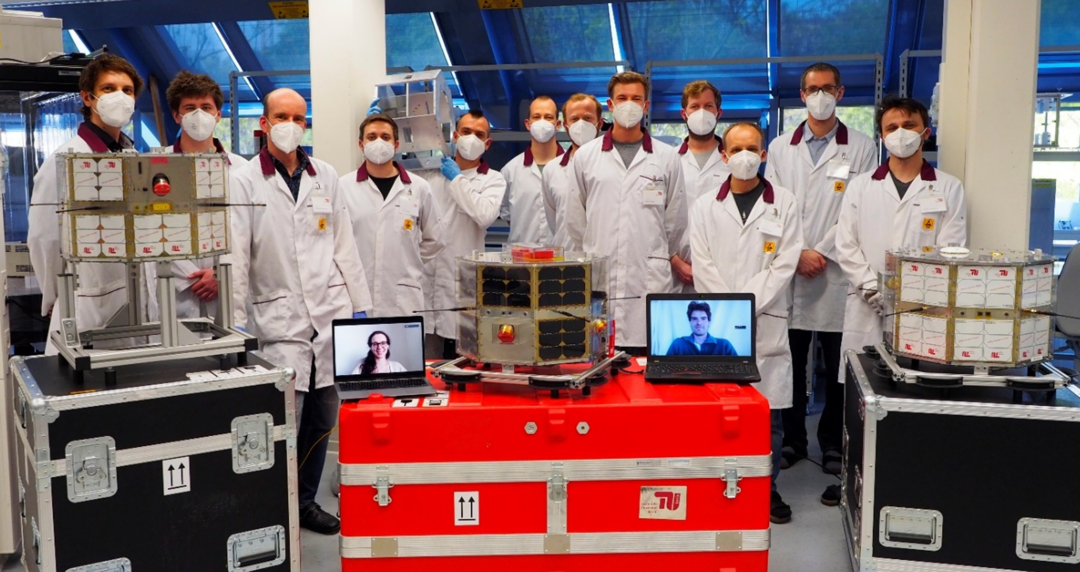
TUBIN
Project Facts
| Project Name | Nano Satellitenmission für Forschung, Entwicklung und Ausbildung (TU Berlin Infrarot Nanosatellite – TUBIN) |
| Duration | 01.04.2020 - 31.03.2024 |
| Funding number | DLR FKZ 50 RM 1102 |
Partners
The project is carried out in cooperation between the following partners:
Technical University Berlin, Chair Space Technology, DE
University of Würzburg, Chair "Information Technology for Aerospace" (ILR-Wue), DE
Funding & Acknowledge
TUBIN is supported by German Aerospace Center (DLR) Space Agency (Raumfahrtmanagement) with funds from the German Federal Ministry of Economic Affairs and Technology (BMWT), Grant No 50 RM 1102
Project Description
TUBIN (Technische Universität Berlin Infrared Nanosatellite) is a university satellite mission with the objective to demonstrate novel Earth remote sensing technologies for nanosatellites. Since power and size limitations prove prohibitive to accommodating cooled HgCdTe infrared detectors on a nanosatellite, TUBIN carries two uncooled microbolometer imagers. In addition, a third imager with sensitivity in the visible spectrum complements the infrared payload. The ground resolution of the thermal images is 150 m. Due to the much smaller pixel size, the images of the visible spectrum camera has a ground sample distance of 38 m.
Following the TechnoSat mission, TUBIN is the second satellite based on the TUBiX20 satellite platform of Technische Universität Berlin. Secondary mission objectives are:
- the on-orbit verification of the high accuracy configuration of the TUBiX20 attitude determination and control system,
- the in-orbit demonstration of the XLink S- and X-band transceiver of Berlin based company IQ Spacecom and
- the evaluation of a refined assembly of 10 mm commercial-off-the-shelf (COTS) corner cube laser reflectors
TUBIN launched into 530 km SSO on board SpaceX’s Transporter-2 mission with a Falcon-9 rocket on June, 30th, 2021 and has been operated continuously to date.
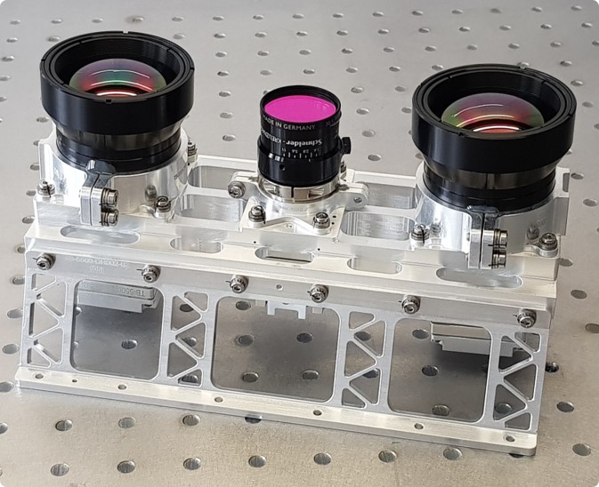
Payloads of TUBIN
Optical Sensors
The TUBIN payload consists of three optical sensors mounted on a optical bench. Here, two thermal infrared (TIR) vanadium oxide (VOx) sensors are mounted at an angle to extend the field of view so that their combined image width corresponds to the image width of the visual sensor (VIS). The VIS sensor in particular is necessary for georeferencing the high temperature events.
Each of the three optical sensors is equipped with the same set of three printed circuit boards (PCBs):
- Interface Board: Enables communication between payload and satellite platform via Ethernet
- Processiong Unit: Allows direct image data processing on the camera itself
- Power Unit: Supplies the sensors with energy
| Thermal Infrarot (TIR) | Visual (VIS) | |
| Sensor Technology | VOx microbolometer | CMOS matrix |
| Optics | Fixed focus, Germaniumarsenide (GeAs) lens | Fixed focus, near-infrared (NIR) filter |
| Pixel Pitch | 17 µm | 1,67 µm |
| Frame Format | 640 x 512 px | 3664 x 2748 px |
| Ground Sampling Distance | 150,1 m | 38,7 m |
| Swath (combined) | 96 km (142 km) | 142 km |
| Wavelength | 7,5 - 14 µm | 380 - 700 nm |
X-Band Transceiver
The XLink from the Berlin-based company IQ Spacecom makes it possible to send data up to 56 Mbit/s in the X-band range from the TUBIN satellite to the ground stations of the Technical University of Berlin. The XLink supports the upload of telecommands in the S- and X-band range.
| Downlink frequency | 8025 - 8500 MHz |
| X-Band uplink frequency | 7145 - 7250 MHz |
| S-Band uplink frequency | 2025 - 2110 MHz |
| Maximum RF output | up to +30 dBm |
| Downlink data rate | up to 100 Mbit/s |
| Modulation | BPSK, QPSK, 8PSK |
| Uplink data rate | 64 kbit/s |
| Data interface | Ethernet, SPI |
| Power consumption (Transmit) | 15 W |
| Power consumption (Receive) | 4,5 W |
| Operating temperature | -20 - 50 °C |
| Dimensions | 90 mm x 65 mm x 25 mm |
| Mass | 200 g |
Vicarious Calibration
Using natural sites
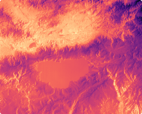
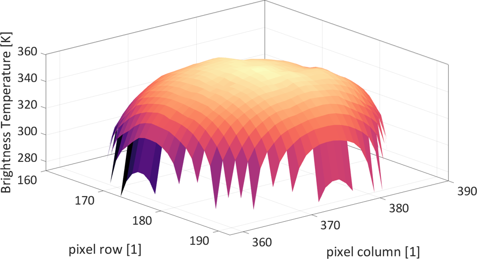
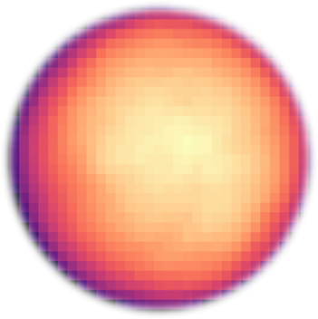
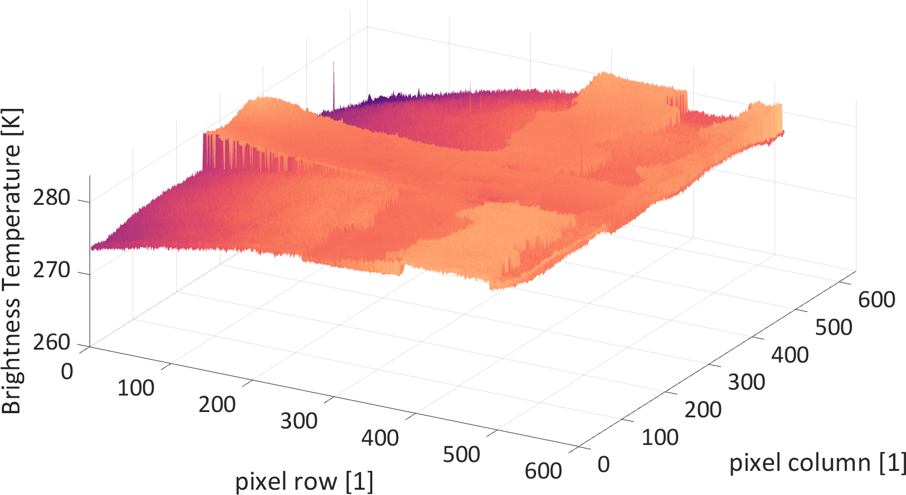
Vicarious calibration is a means of calibrating space sensors by comparing the sensor response to suitable radiation sources. In the thermal infrared, potential sites include lakes, oceans and even celestial bodies. For TUBIN, Lake Tahoe in the Western United States and the full Moon have been selected. Lake Tahoe can be imaged every 17 days on average. It is monitored by NASA through permanently moored buoys dispersed across the lake.
Data collection and Processing
Before and after each imaging campaign, the satellite was pointed towards free space to take zero signal frames to account for sensor offset and artifacts. For data acquisition, the satellite was pointed in nadir direction to image the lake.
Nominally, measurements were performed every three seconds but the rate can experimentally be increased to around 560 ms on average. Seven imaging campaigns were conducted targeting Lake Tahoe. The lake was at least partially featured on five to six images per campaign while a single campaign featured an increased frame rate and thus generated a total of 25 images. Some data was compromised by clouds, a smoke screen, and inhomogeneous readings of the lake and thus was excluded. Due to adverse conditions, only three of the seven conducted campaigns featuring Lake Tahoe could be considered resulting in 120 images. Additionally, one imaging campaign was conducted targeting the full Moon capturing a total of 120 images.
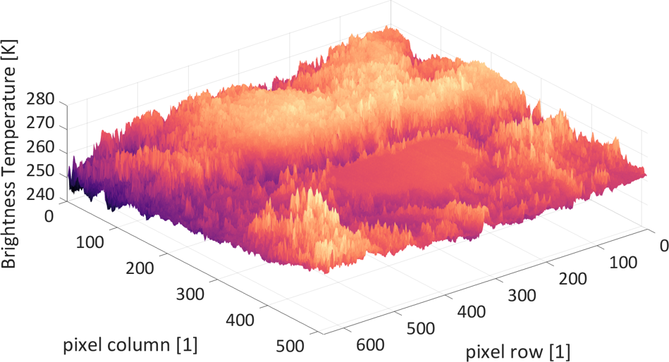
Interpretation of the data
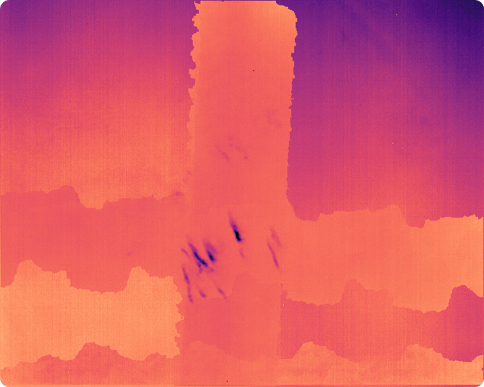
The sensor response exhibited noticeable gradients coherent among all images after processing. Lake pixels were extracted to create a flat-field image for the examined pixels. The relative pixel response was within five percent of the average value for 90 percent of pixels and within ten percent of the average value for 99 percent of all examined pixels. Approximately 43 percent of the microbolometer pixels were re-calibrated which is expected to improve the wildfire detection capabilities. To estimate its performance, the flat-field correction was applied to an image of the Gulf of Mexico. The standard deviation among the corrected pixels could be reduced from 1.5 K to 0.47 K. The detectability of features such as the clouds remained high in the corrected imagery.
Future Works
The response of the non-calibrated pixels can be determined using the newly-calibrated pixels. This can be done by imaging the same part of the ocean within a single imaging campaign. Doing so, the entire sensor can be calibrated in one campaign at the cost of accuracy. Additionally, Lake Tahoe also enables an absolute calibration of the sensor given the in-situ measurements provided by NASA and an atmospheric transmission model for the time of the imaging. Upon evaluation, the full Moon data will further allow for absolute calibration of the imagers.
Earth Observation with TUBIN
From the TUBiX20 family
TUBIN is part of the TUBiX20 satellite family from the TU Berlin. The TUBiX20 satellite platform developed in 2019 was first implemented on the TechnoSat satellite. The focus here is on modularity and scalability of the system. Small satellites with a wide variety of payloads have been and will continue to be integrated on the TUBiX20 satellite bus.
In addition to the detection of high-temperature events by TUBIN via microbolometers from low earth orbit, TechnoSat demonstrated a wide range of payload technologies. QUICK³ is the first to investigate quantum theories in zero gravity on a satellite platform developed by the Chair of Space Technology. The QUEEN project is investigating the applicability of optical quantum technologies on nanosatellites.
Team Members
At the TU Berlin, the following members of the team are employed on the project:
- Julian Bartholomäus, project manager, payload design
- Philipp Werner, deputy project manager, software development and satellite operations
- Anton Große-Siestrup, student assistant satellite operations
- Clément Jonglez, attitude control engineering
- Mara Krachten, student assistant satellite operations
- Julius Léglise, structural and thermal design
- Christian Meumann, electronics development
- Steffen Reinert, satellite operations and AIV
- Mario Starke, software development and satellite operations
- Philip von Keiser, software development
The following team members were previously involved in the project:
- Merlin Barschke, former project manager and systems engineer
- Frank Baumann, former project manager
- Walter Ballheimer, payload design
- Christian Brose, electronics development
- Alexander Burnicki, student assistant satellite operations
- Jens Daniel, student assistant
- Karsten Gordon, attitude control engineering
- Alexander Graf, student assistant
- Luna Gräfje, software development
- Juan Maria Haces Crespo, structural and thermal design
- Balthasar Jäger, student assistant attitude control engineering
- Stefan Junk, electronics development
- Daniel Just, structural and thermal design
- Elizabeth Klioner, student assistant attitude control engineering
- Danilo Költzsch, structural and thermal design
- Jakob Kühn, student assistant
- Cloe-Marie Mora, student assistant satellite operations
- Sven Rotter, student assistant electronics development
- Anton Springer, student assistant structural design
- Christian Tiedemann, student assistant
- Carl-Ludwig Wonneberger, student assistant structural and thermal design
- Lars Zander, electronics development
Contact
| Organization name | Space Technology |
|---|---|
| Office | F 6 |
| Building | F |
| Room | F |
| Organization name | Space Technology |
|---|---|
| Office | F 6 |
| Building | F |
| Room | F |